


 English (pdf)
 Article in xml format
 Article references
 Send this article by e-mail
 Cited by SciELO
  Similars in
SciELO
Similars in
SciELO 
 Permalink
1 Introduction
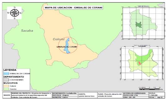
In the department of Cochabamba, Bolivia, the national electricity company ENDE built the Corani artificial reservoir in the 1960s to supply water to the Corani and Santa Isabel hydroelectric plants. Before the construction of the reservoir, the valley floor was used for agriculture. The reservoir is developed at 3.245 m a.s.l. (maximum level), with 1.420 ha flooded and a storage volume of 142 million m3 (ENDE Corani, 2023). The dam is located on the Corani River, downstream of the city of Colomi; it receives water from the upper basin of the Colomi, Kanko, Candelaria and Kayarani Rivers and, since the end of the 1990s, from other basins. After Santa Isabel, the San José 1 and San José 2 power plants were built in 2019. This is a cascade hydroelectric system, with a single reservoir and four successive power plants.
As an annual regulation reservoir, it stores water during the rainy season and contributes to meet the requirements of the national electricity system. Towards the south and southwest, the relief consists of an extensive plain with a low slope.
It has been observed that some months of the year, during the dry season, the water level retraction to the north, drying out the south and southwest of the reservoir, which is used by farmers to plant some crops, mainly potatoes (Solanum tuberosum). This activity seems to be consolidated, as it is repeated year after year and there is no opposition from social organizations or the power company.
Similar situations of partial and temporary land occupation of an artificial lake are not reported (see for example, IFC, 2018;IHA, 2018;van der Ploeg & Vanclay, 2017;ENERGETICA, 2020). Currently, it is not described how the activity of partial occupation of the Corani reservoir lands is developed, how it is inserted in the regional agricultural calendar, its eventual environmental and social implications and, being that the loss of land caused by an artificial reservoir is one of the most significant irreversible negative environmental impacts, it is pertinent to study if it can constitute an environmental mitigation measure.
In this context, the research aims to study the partial and temporary use of the lands that occur in the reservoir during low water levels (dry season), to improve the socio- environmental management of hydroelectric projects. The objectives are:
To study the characteristics of the partial and temporary agricultural use of land by farmers in the reservoir area when there are dry areas usable for agriculture. Analyze its implications.
Propose an environmental mitigation proposal for the irreversible loss of soils, due to the creation of the reservoir.
Propose environmental indicators that reflect the sustainability of the hydroelectric project, due the temporary use of the reservoir soils in agriculture.
2 Methodology
2.1 Satellite image processing
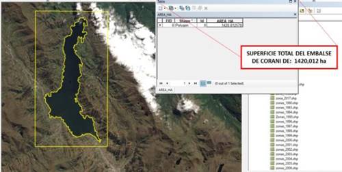
For the processing of satellite images, the intersection of geographic information layers of LANDSAT 5 and 8 images, available in USGS EarthExplorer (USGS, 2022), was carried out. For image classification, the spatial, spectral, temporal, and radiometric resolution, and the maximum percentage of cloudiness in the image (maximum 10-20%) were considered for the period 1990 to 2021, which, considering such restrictions, were reduced to 24 years studied. The geoprocessing for the combination of the multispectral bands was performed with ArcGIS software; then the vectorization/digitization of the total surface of the Corani reservoir was performed with a total surface of the lake (full reservoir) and partially dry (low water), year after year.
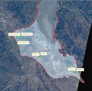
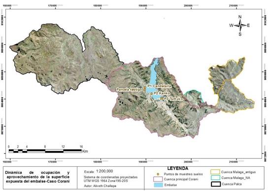
The vectorization/digitization focused on the areas of the reservoir corresponding to the communities of Candelaria, Kanko and Tumuyo, to the southwest and south of the reservoir, because these are the dry areas that are used for agriculture.
2.2 Soil analysis
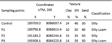
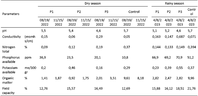
To corroborate the suitability of the soils for agriculture, soil samples were taken and processed by the Soil and Water Laboratory of the Faculty of Agricultural, Livestock and Forestry Sciences of the Universidad Mayor de San Simón. Samples were taken from three points of land that flood during the rainy season (Candelaria-Kanko, Tumuyo) and from a control point that does not flood (Candelaria sector).
The soil sampling coordinates of the cultivated area and the control plot are shown below.
2.3 Determination of Power Density
To determine the environmental sustainability of the hydroelectric project, the Power Density was calculated for the following scenarios: i) full reservoir (design, rainy season) and ii) partially empty (dry season).
To apply to the specific case, the Power Density has been calculated considering the four power plants of the system fed by the Corani reservoir (Corani, Santa Isabel, San José 1, San José 2). The power of the plants has increased over time because of repowering, the addition of generating units or the commissioning of new plants; therefore, the total power varies over time. Power data was obtained from National Dispatch Center (CNDC) and was expressed in megawatts or watts (MW, or W).
The surface area of the full reservoir is one. The water surface during the dry season varies from year to year. Therefore, there are two water surfaces per year: rainy months (full, approximately 6 months) and dry months (partially dry, approximately 6 months). The two surfaces are expressed in Hectares or square meters (Has, or m2).
The basic equation for the calculation of the Power Density is as follows:

Where:
PD: Power Density (W/m2, or MW/ha)
P: Installed power at the hydroelectric power plant (W, or MW)
S: Reservoir Surface (m2, or ha)
The two Power Densities were calculated for the full and partially dry reservoir scenarios.
3 Results and analysis
3.1 Characterization of the temporary use of the reservoir and agricultural calendar
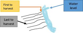
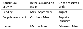
The area of the reservoir that dries up and becomes available for agriculture is dependent, in time and space, on the withdrawal of water (Figure N° 5), which begins from March-April onwards, reaching its maximum area in approximately August-September each year. The surface area varies from year to year as it depends on the hydrological regime and the operation of hydroelectric power plants.
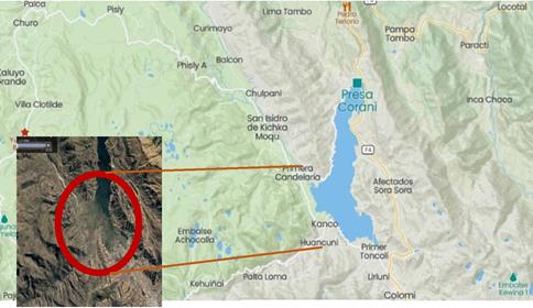
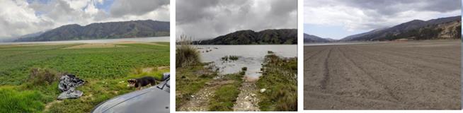
Photo 1: Agricultural use Candelaria sector: Area planted (1 2/2/2021), flooded (04/06/2022) and prepared for planting (08/19/2022), respectively.
The agricultural calendar starts in August when land preparation is carried out; sowing takes place in the same month. Conventional cultural practices common in the region are applied, including the use of fertilizers and pesticides. Harvesting takes place in February-March of the following year, mainly conditioned by the constant increase in the water level of the reservoir due to rainfall; harvesting is usually carried out gradually, starting with those rows closest to the reservoir water and leaving the peripheral rows for the end, thus extending the growing season. If the water increase is more rapid and the crop is not yet mature, then it is harvested and marketed as fodder.
The agricultural calendar is like the one applied throughout the region, although it is much more widespread in the region2.
A closer look revealed that not all the dry land is used for agriculture; it is estimated that 20% of the dry land is natural accidents that impede agriculture ("roads", muddy areas, riverbanks, river streams).
The quantification of the exposed and therefore dry surfaces, those that are cultivated and the reservoir that remains with water left over, is presented in Table N° 3.
Table 3. Estimation of dry, effectively cultivated and remaining water areas. Máximum lake surface (full reservoir): 1.420 ha.
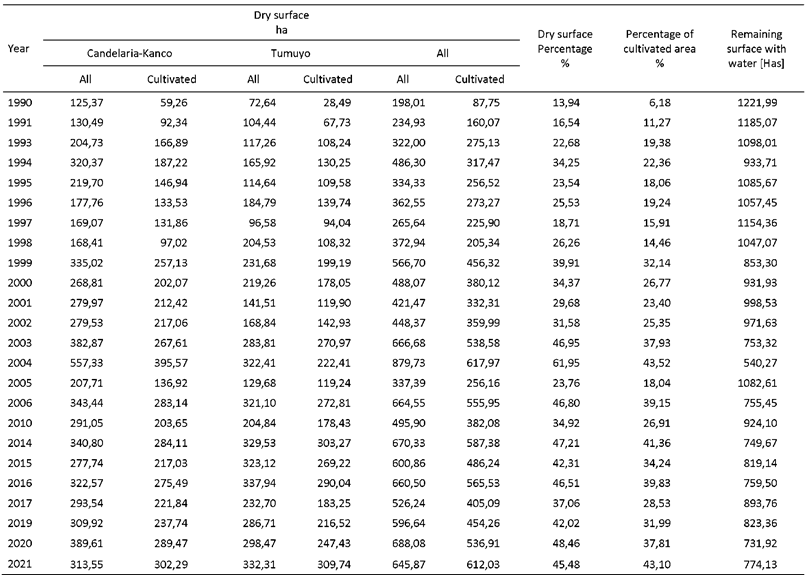
Of the total area of the full reservoir, 1,420 ha, the dry area ranged from 13.94% in 1990 (minimum dry area) to 61.95% in 2004 (maximum dry area). In other words, in 2004, 879.93 Ha dried up and became available for agriculture, leaving only 540,27 ha available for hydropower generation. The inter-annual variation shows the tendency of the dry surface to increase in recent years, which is generally of the order of 40%. This percentage is very significant and shows the high potential for agriculture in the reservoir area.
If we exclude the non-cultivable areas for the years mentioned, the cultivated area ranges from 6,18% (1990) to 43,52% (2004) of the total reservoir, i.e. in 2004, only 617,97 ha of the reservoir were cultivated, out of the potential 879,93 ha. The cultivated area is relevant.
3.2 Crops
The most widely grown crops are "potatoes" (Solanum tuberosum, varieties "waycha" or "holandesa"), "broad beans" (Vicia faba), "oca" (Oxalis tuberosa), "barley" (Hordeum vulgare), "oats" (Avena sativa), which is consistent with the crops grown in the region. Production is mainly, but not exclusively, sold on the local market.
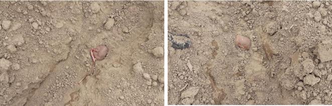
In the reservoir, cultural practices aimed at shortening the growing season can be observed, such as the planting of "potatoes" with some root development (see Photography N° 2, Kanko plain). This is considered to be a strategy in response to the short agricultural calendar, i.e. a crop with a short vegetative cycle, as anticipated by Navia (2008).
Agriculture is carried out in such a way that it does not affect the main activity, which is hydroelectricity, with no perceived incompatibilities.
3.3 Soil quality of the cultivated area
The physical properties of the soil in the study area, as well as the physic-chemical parameters, indicate that they are suitable for "potato", "broad bean" and "pea" agriculture. This is consistent with the characteristics of the ecological floor of Puna, as well as with the taxonomy of the soils.
The control plot is permanently fallow and has a natural vegetation layer, so its organic matter content is higher, while in the other three plots natural fertilizers such as "chicken manure", "rice husk" and other N-P-K fertilizers are applied. Navia (2008) confirms that 18-46-0, "chicken manure", or "urea" fertilizers are indeed often used. The possible impact of nutrients on soil and water quality deserves further study.
Compared to the control plot, the Phosphorus and Nitrogen analyses suggest that the addition of fertilizer guarantees high "potato" yields. It has been observed that the macronutrient Potassium is one of the most limiting nutrients in crops (Toledo, 2016), being more susceptible to leaching due to the influence of the reservoir drainage (Cáceres, 2022). Comparing the control plot and the cultivated plots, the differences could be attributed to the fact that the former is a resting soil and not subject to flooding, so the soil structure is more stable and has a medium porosity.
At the beginning of the rainy season, an increase in the organic matter parameter is observed. This is confirmed by the fact that the herbaceous plant "chamomile" (Matricaria chamomilla), which is characterized by growing in fertile soils rich in organic matter (Ministry of Sustainable Development, 2003), was widely observed in the study area.
Therefore, the soil quality of the flooded land is suitable for agriculture in terms of its physical and chemical properties. Farmers also say that good yields are obtained.
3.4 Access to flooded land: de facto right of inheritance
One aspect that needed to be clarified was how access to the reservoir land would be determined, given that the land is owned by the electricity company. In the field, it was found that there was no controversy over access and that it was accepted by the social organizations.
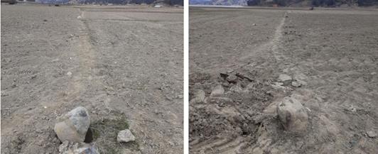
According to the information gathered, access to the reservoir land is by the descendants of those who once owned the land when the reservoir was created and expanded in the 1960s - 1990s, i.e. to date, essentially the third generation. Such access is without legal title to the land. On the site there are forms to demarcate the land (Photography N° 3).
This access would demonstrate that the right to occupy and use the land has not been extinguished, despite the transfer of title to the electricity company. This suggests that there is a "de facto right of inheritance". It could be interpreted that the former stakeholders of the past, the owners of the flooded land, are regaining roles and importance through their descendants.
One aspect that needs to be studied is how these land access rights are transmitted or inherited to other generations.
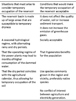
3.5 Mitigation proposal: Temporary occupation of the reservoir
The first negative, direct, irreversible environmental impact of the creation of an artificial reservoir is the loss of soil, with all that this implies: the displacement of the human population, their activities and belongings, the loss of services, cultural, socio-economic, tourism and biological resources, among others (IFC, 2015). It therefore challenges to find mitigation measures.
The use of an area of the reservoir initially lost by flooding, even temporarily, constitutes a migration from irreversibility of the negative impact to mitigability, thus reducing the severity of the negative impact.
Based on this case study, it is proposed to consider as a mitigation measure the temporary occupation of the reservoir area, under controlled conditions and when the characteristics of the reservoir and the hydroelectric activity allow it. The situations and conditions that would allow it are shown in Table N° 5.
This measure allows:
Decrease the area effectively lost by the creation of a reservoir and thus the severity of negative environmental impacts.
Improving the sustainability of the hydropower Project.
Re-establishing the lost productive system and social links. A source of income is created.
Contributing to the social acceptance of the project.
3.6 Proposal of environmental indicators
The creation of an artificial reservoir, in addition to the positive impacts inherent in the motivation for the project, has widely recognized negative environmental and social impacts, including the loss of flooded land.
Within the framework of this research and with the elements collected, two indicators are proposed that can be incorporated into the environmental management tools for artificial reservoirs.
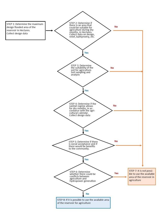
3.6.1 Indicator Temporary surface availability
The direct indicator for determining the possibility of using this mitigation measure is the availability of usable area for agricultural activities.
In the case of new hydropower projects, it is possible to determine at the study stage whether there will be land available for agricultural use if (see also Table N° 5):
The bathymetry and characteristics of the basin suggest that there may be areas that could be used for agriculture.
Soil quality is suitable for agriculture.
The rainfall and water use regime leads to periods of low water levels.
There are not affected the water requirements by the hydroelectric power plant.
In the positive case, it is plausible to consider temporary land occupation as a mitigation measure. The larger the usable agricultural area, the higher and more significant the contribution of the mitigation measure will be. Figure N° 7 shows the decision flow chart.
3.6.2 Indicator Average Power Density
The sustainability of a hydropower project can be determined through the Power Density (PD) indicator, which expresses the ratio between the power of the hydropower plant and the surface area flooded to satisfy the requirements of the plant3. The higher the ratio, the more sustainable the hydropower project will be.
Table 6 Calculation of Power Density, with full and remaining reservoir (Power is the sum of the four power plants: Corani, Santa Isabel, San José 1 and San José 2). Maximum lake surface (full reservoir): 1.420 ha. C: Corani Hydro plant, S: Santa Isabel Hydro plant, SJ1: San Jose 1 Hydro plant, SJ2: San Jose 2 Hydro plant.
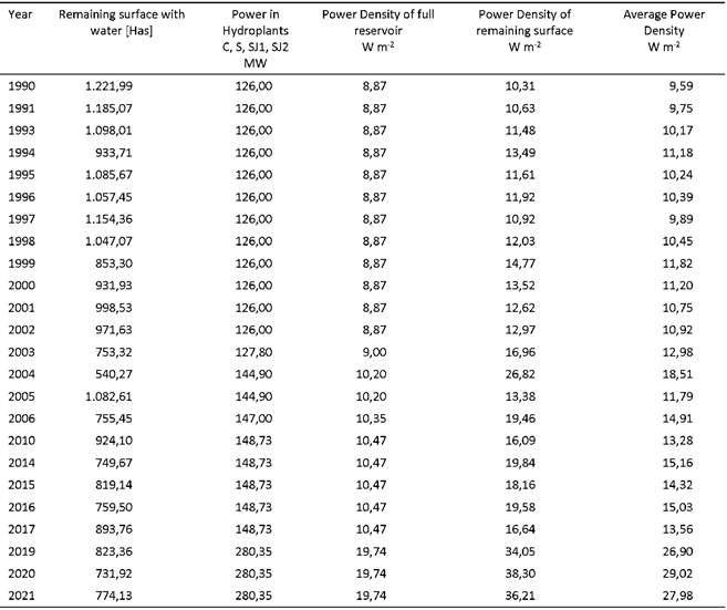
In the usual calculation this indicator considers only the full reservoir as the only scenario. However, as described in this case study, the water surface in the reservoir may be less in some months of the year (dry season), so that the PD is higher than in other months of the year.
Currently, the Corani reservoir feeds four hydroelectric power plants arranged in cascade: Corani, Santa Isabel, San José 1 and San José 2, i.e. there is only one reservoir (one flooded area) to serve the turbines of four power plants. Table N° 6 shows the PD calculated for the two scenarios, expressed in W m-2.
The Power Density has a one value when the reservoir is full, and another, higher value when the reservoir is partially dry - and cultivated. By way of example, for the year 1990, the DP = 8,87 W m-2 considering the reservoir full (rainfall), rises to 10,31 W m-2 with the reservoir partially dry (low water) and, for the year 2004, DP = 10,20 W m-2 rises to 26,82 W m-2, respectively4. Environmental sustainability improves, because for the same installed capacity in the power plants, the area flooded is smaller5.
The two Power Densities have an approximate duration of half a year each (for full and partially dry reservoir, 6 months each). The actual Power Density calculated for a hydroelectric project should reflect both scenarios. Therefore, it is proposed to calculate the arithmetic average of the two scenarios. Generalizing and considering the possibility of different time periods (full and dry months), so that the influence of these can be weighted, the formula for average Power Density would be:

Where:
PDa: Power Density average [W m-2]
Mt: 12, total Months of the year (Mf + Md)
Mf: Number of Months with full reservoir (design)
Md: Number of Months with dry reservoir (observed or estimated)
P: Installed power in hydroelectric plant [MW]
Sf: Full Surface Reservoir [Hectare] (design)
Sr: Surface of reservoir with remaining water during dry season [ha] (observed or estimated)
The "average power density" of the reservoir will allow a better characterization of the sustainability of the hydropower project.
4 Conclusions
a) Agriculture is practiced in the temporarily dry areas of the artificial reservoir of Corani, in an area that varies from year to year, depending on the rainfall regime and the operation of the hydroelectric plants. The maximum dry area observed during the period under study was in 2004, when it reached 61,95% of the lake (1.420 ha), while the area actually cultivated reached 43,52%, corresponding to 617,97 ha.
Cultural practices have been adapted to the conditions imposed by the climate, the length of the rainy season and the dynamics of water use by the hydroelectric plant, without affecting it.
Agriculture is at farmer's risk.
b) Today's farmers are the descendants of the former landowners who were flooded when the artificial reservoir was created and who were compensated financially or in kind, thus creating a de facto right of inheritance.
The access to the land has been socially accepted by the villagers as well as by the electricity company.
Soil quality is suitable for agricultural development, especially for tubers. The application of fertilizers and pesticides could alter water and soil quality.
c) The negative environmental impact of soil loss caused by the creation of the artificial reservoir, conceptually considered irreversible, can be considered mitigable and applicable in certain cases in the light of this research. Therefore, it is proposed to consider it as a mitigation measure when dealing with the creation of reservoirs.
In addition to the social benefits of this measure, it contributes to greater efficiency of the hydroelectric complex.
It is conceivable that a reservoir designed as a single- purpose reservoir (in this case hydroelectric) could acquire a broader character, even migrating to a multi-purpose reservoir, as it would serve the requirements of other sectors, such as agriculture in this case.
d) In cases where the artificial reservoir partially dries up, there are two Power Densities of approximately half a year each: i) calculated with the full reservoir, and ii) calculated with the reservoir partially dry. This leads to an improvement in environmental sustainability, as the flooded area is smaller in some months of the year for the same installed capacity. The average Power Density of both scenarios is proposed as an indicator of real environmental sustainability. A calculation formula is suggested.

